Incredible.
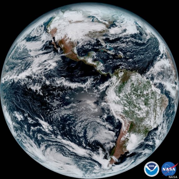
A new satellite launched by NOAA, U.S.'s environmental research agency, sent back some of the clearest photos captured of planet Earth.
The GOES-16 satellite, sent into space in November 2016, has the ability to capture full-disk photos of Earth every 15 minutes with its Advanced Baseline Imager instrument (ABI).
Click the images below for a closer look.
![earth nasa]()
The western hemisphere is shown in a image captured by GOAT-16.
The "game-changer" satellite serves an important purpose.
"The image is much more than a pretty picture, it is the future of weather observations and forecasting," said Louis W. Uccellini, the director of NOAA.
![earth nasa]()
The Caribbean shown in a image captured by GOES-16.
The satellite's quick image-capturing abilities allow it to target regional areas where severe weather such as hurricanes may be approaching, in as quickly as 30 seconds.
It's revolutionary for meteorologists, who can zoom into active areas with a clearer focus than before — and potentially life-saving at times of natural disaster.
Watch the video above for more images from the satellite, and click here for even more.
Follow The Huffington Post Canada on Facebook, Twitter, and Instagram.
A new satellite launched by NOAA, U.S.'s environmental research agency, sent back some of the clearest photos captured of planet Earth.
The GOES-16 satellite, sent into space in November 2016, has the ability to capture full-disk photos of Earth every 15 minutes with its Advanced Baseline Imager instrument (ABI).
Click the images below for a closer look.

The western hemisphere is shown in a image captured by GOAT-16.
The "game-changer" satellite serves an important purpose.
"The image is much more than a pretty picture, it is the future of weather observations and forecasting," said Louis W. Uccellini, the director of NOAA.

The Caribbean shown in a image captured by GOES-16.
The satellite's quick image-capturing abilities allow it to target regional areas where severe weather such as hurricanes may be approaching, in as quickly as 30 seconds.
It's revolutionary for meteorologists, who can zoom into active areas with a clearer focus than before — and potentially life-saving at times of natural disaster.
Watch the video above for more images from the satellite, and click here for even more.
Follow The Huffington Post Canada on Facebook, Twitter, and Instagram.
-- This feed and its contents are the property of The Huffington Post, and use is subject to our terms. It may be used for personal consumption, but may not be distributed on a website.